
Organizing the gear and packing the load at North Lake. We hit the trail at 2 PM after driving from the SF Bay Area, picking up a permit, and having some lunch.

The "lower" elevations in this area (meaning 9,000'-10,000') feature Aspen trees, which are just starting to turn. Surprisingly, there is a fair bit of red in the leaves at this early stage. Fall in the mountains has arrived!

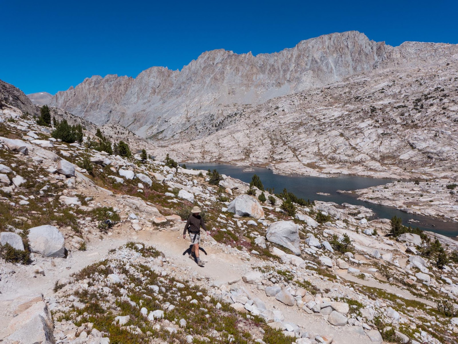
As we climb up from North Lake on the gentle Piute Pass trail, we begin to take in views looking back to the East from where we came.

Another view looking back to the East, with Piute Lakes. Almost to the Pass!

Cresting the Piute Pass, we start down the trail for just a few hundred meters, before heading South, and going cross country.

It's an easy 1 mile hike from Piute Pass to Muriel Lake, where we will set up camp. We hike steady, not fast, but with minimal stops, in order to make the 6 mile climb over the Pass and arrive at the lake in time to set up camp and cook dinner.

Mt. Humphries in the distance as we pass a tarn on the way to Muriel Lake.

Time is short, and suddenly, it's gotten windy and cold, so we work quickly to set up camp and enjoy dinner in the evening light.

After carrying the packs for 3.5 hours on Day 1, we decide it's time to take a day off and explore the Humphries Basin on a day hike. We hike back toward Piute Pass to keep our elevation while we head North toward Mt. Humphries, and we bypass Summit Lake below us.

Our goal for the day is to explore the Humphries Lakes, and then check out Desolation Lake (in this photo), which is the largest lake in the Basin at 11,375'.

 |
| Photo by Sarah Schroer |

Our camp at Muriel Lake. Mt. Humphries, 13,986', presides over the Humphries Basin like no other Peak in the Sierra. I cannot think of another location where one Peak is so dominant. It's a massive obstacle, and there is no easy way to climb it. I will never see the view from the summit, though many skilled climbers have had the pleasure.

I enjoy camp at Muriel Lake. Photo by Sarah Schroer

While Mt. Humphries looms to the North, looking to the South East, we see the moon rising over Muriel Peak, 12,937'.

Evening falls on our second night, wind dies, and the lake is placid. The temperature dips to the low 30's. We'll see much colder nights in the next few days as a cold front passes.

With the freezing morning temperature, there is no getting out of the tent until the sun hits, so our next adventure, a cross country hike over Alpine Col, is slightly delayed. Once the sun is out, it's a splendid hike leaving Muriel Lake and Mt. Humphries behind.

I head toward Goethe Lake. Alpine Col is past the Lake and up to the left. Photo by Sarah Schroer

From Goethe Lake, below Alpine Col, the trouble begins. Acres and acres of large talus, lots of work, and not that much fun.

We slowly, very slowly, make our way toward Alpine Col. Sarah is dwarfed by the large talus.

Sarah makes the last few moves toward the Col at 12,400' with the beautiful Goethe Lake as a backdrop... but we're not done yet...

The last couple of moves at the top of the Col look a bit intimidating, but I'd studied the route from far below, and when we got to the cliff ahead, it turned out to be a piece of cake, and my planned route went without any issue. Photo by Sarah Schroer

Surprisingly, the wind is somewhat mild at lunchtime, and we're able to have a nice picnic at the Col, looking South in the direction we are heading, toward the Darwin Basin.

Many wild flowers up very high this time of year in the Sierra.

Alpine Col in the distance, the South side we descended, approximately on the shadow line. The lake is very long, and the talus from the summit down, and all the way along the lake is tedious. The Col took several hours to pass, and we realize we may not make our goal of the Darwin Bench today (Day 3).

With the wind picking up, and another long talus grind around Lake 11,540', we decide to camp at the East end of the lake behind a large boulder to break the icy wind. It helps a bit, but it's a cool evening with the tent flapping all night.

In the morning, with the sun up, winds down, and warmer temps, we work our way around Lake 11,540', and the Darwin Bench, my goal for the next camp, comes into view. It's absolutely gorgeous, and I am inspired taking in the view! Photo by Sarah Schroer

The hard cross country hiking is behind us, and the down climb to the Darwin Bench is easy and pleasurable.

We find a good campsite, or so we think, and then head out with the day packs to explore. I am dying to show Sarah the Evolution Lakes area, where we plan to day hike the next day, so we head out trying to find an overlook. After two disappointments, the third time is a charm, and there is Evolution Lake before our eyes, a splendid view from this vantage point. A coyote below us, spots us, and makes a beeline up the talus, sprinting full speed uphill on the technical terrain. This animal covers in 30 seconds what would have take us probably 15 minutes. It was amazing, and this moment was truly a highlight of the day, and of the trip for that matter.

Enjoying the view down the Evolution Valley from the Darwin Bench. Photo by Sarah Schroer

With still more time in the afternoon, we take another hike down the use trail along the Darwin Creek, which drains into the Evolution Valley.

Sarah's first Marmot sighting is a good one. This animal puts on a good show, feeding voraciously on plants for quite a while as we watch from close range. Time to put on some weight for the Winter!

When it's both sunny and cold, the Two Hat Trick comes into play. Sarah executes to perfection.

As it turns out, we've selected a camp spot that gets later sun in the morning, so our day hike to the Evolution Lakes area is delayed. We hatch a plan to get back to camp early, and move up the bench for better morning sun. In the mean time, it's down the drainage to catch the John Muir Trail through the Evolution Lakes area. I don't like hiking on the John Muir Trail very much, but this particular section from Evolution Lake, to Muir Pass is certainly one of the nicest sections of the JMT, and after a full day of talus hopping, I think Sarah will enjoy this area.

We reach the lovely Evolution Lake.
Returning on the JMT toward Sapphire Lake, above Evolution Lake.

Swimming and bathing has been a challenge on this trip, with nighttime temps in the low 20's and breezy cool days with some clouds. Here Sarah takes the opportunity to give the hair a cold rinse.

I also take the opportunity to dip my head in the water, and Sarah notices a resemblance of my hair and the cliffs behind. Photo by Sarah Schroer

We get back to camp at 3:30 PM, quickly pack up, and are on the trail at about 4 PM. We move camp up the bench, and I've taken a compass reading so we know where the sun will rise. We'll have early sun tomorrow, Day 6. Good thing, since the temp tonight will dip to 21 degrees F at this lake at 11,592'!

The winds have died and we are able to enjoy an amazing moonrise on this evening.

A sunny morning at camp enables us to get out of the tent and enjoy coffee, tea, and sunshine.

Lamarck Col 12,990', is a long climb up from the Darwin Lakes, but the talus is a piece of cake compared to Alpine Col.

Lovely view of Darwin Lakes as we climb toward Lamarck Col.

Mandatory summit shot. Sign tells the hiker that he/she is entering, (in our case leaving), Kings Canyon National Park at the summit.

Descending the Col on the East side has a very short Class 2 section, then the rest of the way to North Lake is easy. Sarah is in the upper middle of the photo.

The hiker then descends a long, sandy valley before dropping down an interesting trail to Lamarck Lakes.

We take a short detour to peer over the cliff to view Sky High Lake, an icy, milky, glacier fed lake. The area above the lake is a glacier, but is covered with scree and talus.

From the same vantage point, the hiker can view the aptly named Wishbone Lake lower down the valley.

Upper Lamarck Lake then comes into view. Sarah and I take an arduous cross country hike around Upper and Lower Lamarck Lakes. I have no photos and do not recommend the hike. 'Nuf said.

Back into the Aspens as we approach North Lake. We get back to the car, then pick up an injured JMT hiker hitching his way back to Bishop. We drop him at the Hostel California, then get a room at the Travelodge, where we shower, change clothes, and head out to the Italian restaurant for a well deserved salad, pizza, and schooner of beer.
10 comments:
On 8-20-2017 I went the same general route, but more direct. Going up Alpine Col was made easier by all the snow, but there was still a lot of big rocks. Going down the west side of the lakes to the Darwin Bench was also easier due to the remaining snow. Lamarack Col was a slog, but a large thunderstorm over Mt Mendel heading north pushed me along. The Darwin Bench is spectacular. Thanks for all the pictures. I have a couple of pictures of all the snow where there was none in yours.
What degree sleeping bags did you folks use? An old guy like me would have been cold in my 15 degree bag that I used when my wife and I were in Humprhey's Basin. We did get sleet one afternoon during a thunderstorm. If I had done your route (which I could not do b/c of the talus) I would have needed my zero degree bag. Norman Clyde has an interesting account of a ski trip in Humprhey's basin where he and his traveling companion were caught in a blizzard and his companion perished. Very nice narrative and photos.
Great write-up--thank you! We did this trip in 2001 (but ending almost the Ionian Basin), and then again in 2009. I swore I'd never do Alpine Col with a 42 lb pack again, but it looks like we're heading that way this summer. If I could ask a question...on Alpine Col, did you ascend hikers' right of the cliff band, through it, or to hiker's left? We have gone to the right both times, and I'm thinking left is steeper, but fewer big boulders. One of our group did the cliff ledge 1/3 back from the far right and said that's a good route. Thanks, Greg.
gstone at pacbell.net
Great write up - thank you. I did this same loop some 30+ years ago with my mom, and have planned it again for this year, this time solo (Mom is still with us, but at 83, this would just be too much now). GREAT to hear your accounts of the temps. My permit is for September 18, and I’m going to see about moving that up as much as I can. With a tent, I was tempted to bring my 35F bag, but that will be swapped out for my 20F’er. May even be wise to take the 0F. For the Col’s, I’ll be taking it easy and carefully. Looking forward to it!
Also, what kind of food solution were you using for bears? With most time above timberline, seems a hanging solution would be impractical. Bear can, or were bears just not a concern? Back when I did it before, that was when it wasn’t mandatory but just recommended to protect your food. Just can’t remember what we did. Any tips would be greatly appreciated!
I used a 30 degree bag, and was a bit cold. The temperatures on our trip were cooler than usual for September, and I'd normally be fine in the bag I brought. I'd bring your 20 degree bag, but do check weather before you go. As you can see, we did have a tent with fly, and there were two of us, so that helps a lot. Above tree line bears are rarely a problem, but you can't be sloppy hanging food. Bring a Bear Cannister, or you can do what I do. I find a very large boulder, like as big as a small house, with an overhang. Then hang the food at least 8' up in the air, and not touching the rock. I've never had a problem with critters, small or large, using this method.
I've hiked to Upper Lamarck Lake. Is there an actual trail to Lamarck Col?
There is no official trail to Lamarck Col. However, from Lamarck Lake, there is a good use trail up to the upper, open valley that leads to Lamarck Col. Once near the Col, there is a good use trail to the pass, though often covered in snow until late season. On the South side of the pass, to Darwin Lakes Basin, it's strictly cross country travel.
I think I remember seeing a trail off to the left (ascending) before getting to the upper lake.
Thanks VERY much for the reply Macpaulster. A 20F bag it is then (was tempted to bring my 35F bag and a liner, but the 20F, and I should be safe. I'll also have a fly I can add to my tent for additional heat-retention. Better to be a bit heavier in the pack than cold at night.
Great idea for the bear and critter deterrent. Were there sufficient "hanging rocks" on your "Col loop"? I assume that you tether/anchor the rope on the topside of the rock. Again, great idea, in the absence of trees.
Post a Comment